The feature of i-gotU micro GPS GT-800pro, and usage
It is convenient if the travel in not a full-scale navigation system but on foot and a bicycle, or Buss has easy Navi. If the direction and distance to the destination are displayed especially, it can go to the destination, without making a mistake. Micro GPS and GT-800pro was purchased and used for this purpose.
GT-800pro GPS receiver's feature
 The product made by Mobile Action Technology of an i-gotU brand of GT-800pro is
micro GPS receiver of high sensitivity. Electronic compass, the barometric altimeter, and the
accelerometer are built in. Furthermore, it has a 1.4-inch LCD display and can
perform record of 200,000 points as a GPS data logger.
The product made by Mobile Action Technology of an i-gotU brand of GT-800pro is
micro GPS receiver of high sensitivity. Electronic compass, the barometric altimeter, and the
accelerometer are built in. Furthermore, it has a 1.4-inch LCD display and can
perform record of 200,000 points as a GPS data logger.
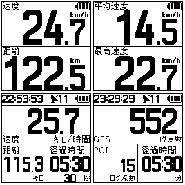
The typical thing of the display of GT-800pro is as it is shown in this figure. Displays various otherwise are possible. All cannot be introduced.
Various kinds of setup and usage
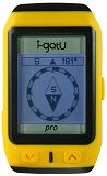
 GT-800pro has a form like this photograph. If attached to an arm, it is
somewhat larger than a big wrist watch. Long aggressiveness Power / Menu button in order to switch on a power supply.
GT-800pro has a form like this photograph. If attached to an arm, it is
somewhat larger than a big wrist watch. Long aggressiveness Power / Menu button in order to switch on a power supply.
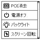
If long aggressiveness Power / Menu button while in use, such an another menu page can be called.
With POI elimination, the POI record currently recorded is eliminable. Since POI made to memorize by a route planner does not eliminate at this time, please feel easy.
Into this menu, power supply OFF and selection of whether a back light is made to always turn on or to erase can also be performed. The display screen displayed on a main screen on a display can be specified. The calibration of pedometer sensitivity, and an altitude indication is also made.
Here, there is a setting screen to the extent that it cannot explain. I think that it understands if it sees. There is a help screen of a way used into @trip PC of bundled software.
A direction sensor, direct Navi
 If ordinary GPS receivers are moving, a direction will be displayed, but since
electronic compass is built in, this GT-800pro can know the direction, even when neither the state where it stopped, nor
the electric wave from a GPS Satellite can not be received.
If ordinary GPS receivers are moving, a direction will be displayed, but since
electronic compass is built in, this GT-800pro can know the direction, even when neither the state where it stopped, nor
the electric wave from a GPS Satellite can not be received.
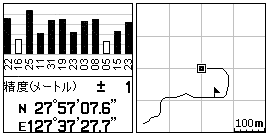
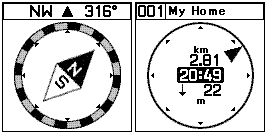
If the point is created on GoogleMap by the route planner of @trip of utiilty software and a GPS receiver is made to record, direct Navi to the registration point can be performed. The direction and distance to the destination are displayed like this screen. Less than several meters of the destination can go easily. The name of a registration point can be changed arbitrarily. Japanese character display is also possible.
In a route planner, a position is memorizable to 100 points (POI numbers 001-100). If the relay point to the destination is registered in order, it can use as route Navi. The additional registration of the point can be carried out also in movement only by pushing a Power / Menu button lightly by a GPS log mark display screen. The POI number in this case is set to 101-999. The route can register only one route.
Although there was information that locative calls are well impossible in a mountain range, as long as I used, there was no such thing. The accuracy of a position and an advanced display were succeeded also on the steep mountain path or the way where the tree grew luxuriantly.
It used in the high way bus to Osaka. In the tunnel, although not displayed, shortly after the direction of the destination came out of the tunnel, it was displayed. Moreover, even while moving by Buss in the inside of a cluster of tall buildings, although the sky can seldom be seen, it was displaying perfectly. It seemed that it was rather highly sensitive.
Uses as GPS running / a cycle computer
Speed, distance, time, average speed, a maximal rate, lapsed time, the number of steps, an altitude, a direction, a locus, etc. can be displayed on a screen. Utiilty software called SportAnalyzer is attached and it can perform management of exercise training.
Uses as a GPS data logger etc.
The locus of a maximum of 200,000 points is recordable at a fixed interval (1 to 60 seconds) as data logger. It can download to a personal computer by attached utiilty software, and can display a locus on a map. Collation of the time of the photograph taken with the digital camera and the position on a map can also be easily performed now.
The barometric altimeter is built in as an altimeter. Since the altitude in GPS is displayed, advanced proofreading is set according to it. It can be used also as a pedometer with an accelerometer. Moreover, it can be used also as a stopwatch.
The calibration method of electronic compass
 When it uses as route Navi, electronic compass may stop operating suddenly in a
train and a building etc. Disorder of magnetism may have influenced.
When it uses as route Navi, electronic compass may stop operating suddenly in a
train and a building etc. Disorder of magnetism may have influenced.
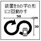
The proofreading method of the electronic compass of GT-800 Pro is what have a main part and be moved twice to a "character of 8" form. However, even if it does how many times, it does not work.
The information on the way of a calibration was looked for on the Internet. It seems that a strap is attached to a main part, and a calibration will be made if it is made to rotate so that a circle may be horizontally drawn on the head.
However, since I do not always have a strap, other methods were considered. It is the method of using the vinyl bag of shopping. A main part is put in a vinyl bag, and it brandishes on the head, and makes it rotate several times.
In order to try proofreading of electronic compass repeatedly, it is necessary to reset. It will be reset if an upper arrow button, and a Power / Menu button are simultaneously pushed for about 5 seconds. Only by a part of setup being reset, since neither route information nor POI information disappears, please feel easy about it.